

Plan campaigns for redistricted seats better with data rich maps
Campaigns have to adapt their plans after redistricting. Good technology makes it fast, simple and affordable.
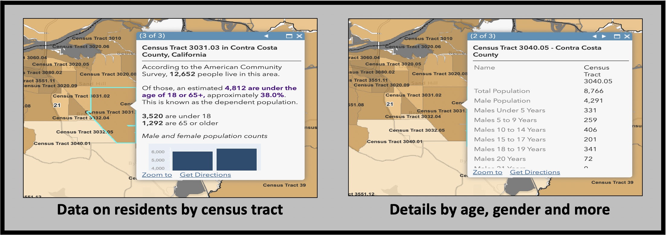
What are the demographics of the new district? Age, income, education, race, language spoken and family size? Where do people live within the district? These factors influence the messaging, outreach and canvassing.
The voter file can provide some of this information, but it doesn’t include residents who aren’t registered to vote. This blog explains how Voter PAC analyzes the California landscape after redistricting as well as:
- How to apply Geographical Information Systems (GIS) to campaign planning
- Sources of affordable demographic data that is independent of the voter file
- How to locate unregistered voters in a district
- Free apps for canvassing with any list of addresses – not just the voter file
- How to get free mapping help with social justice and voter registration projects
Finding competitive districts
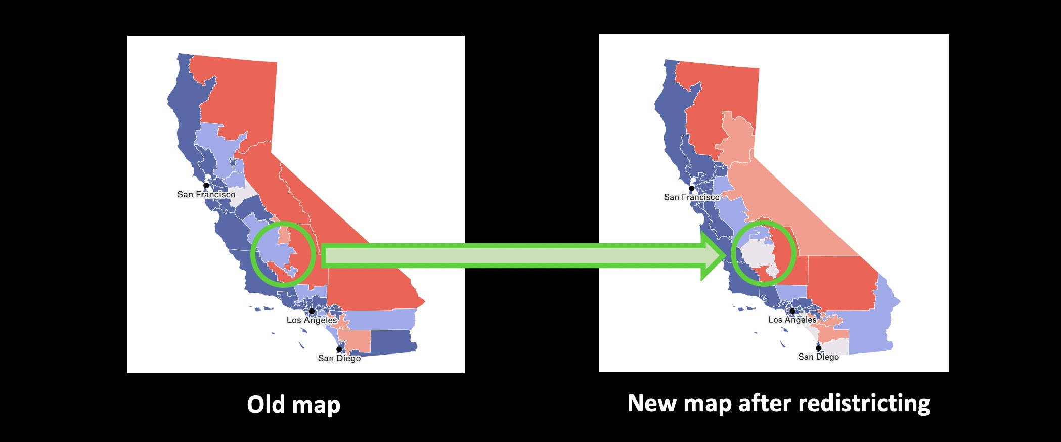
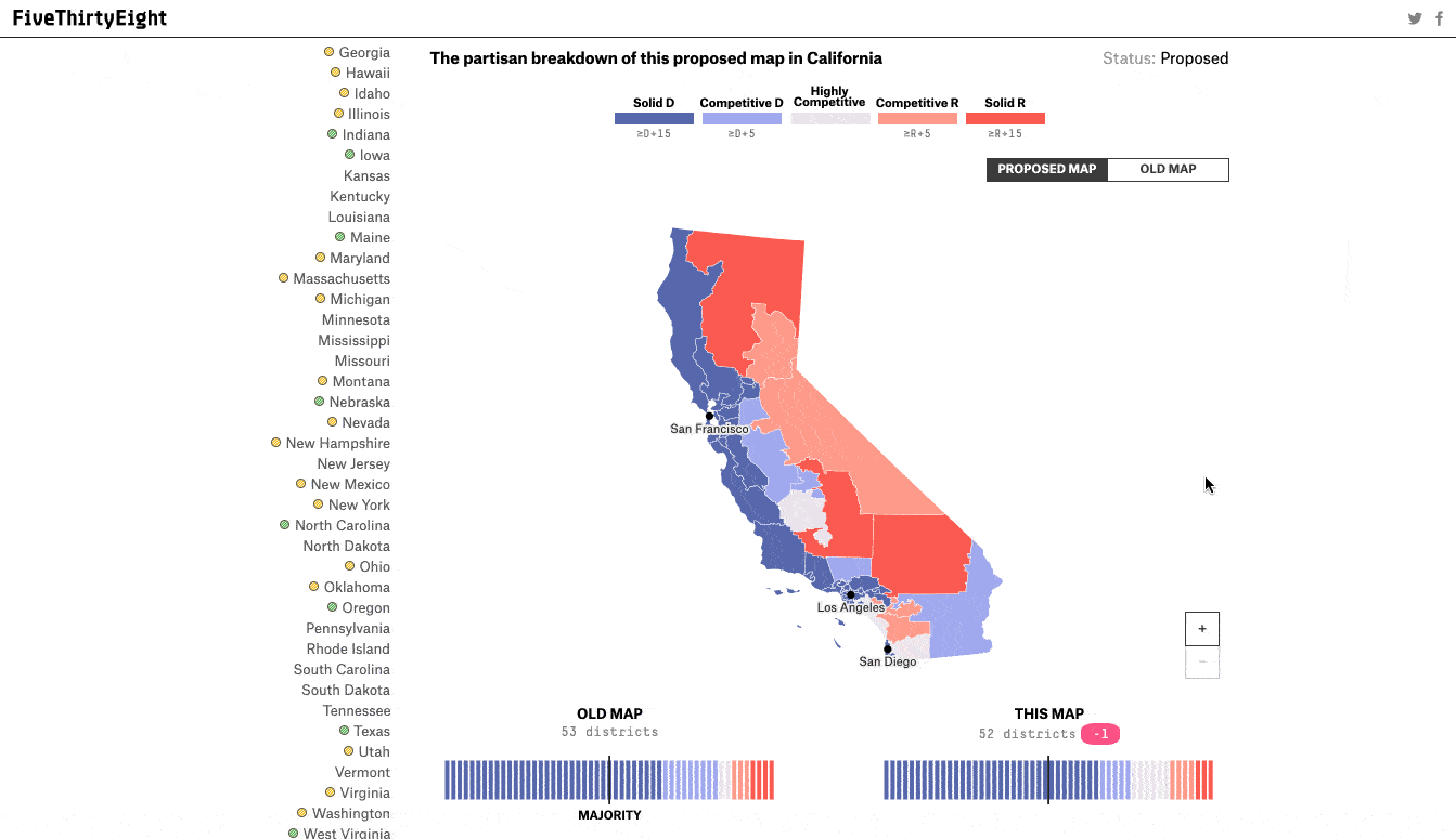
FiveThirtyEight provides a detailed analysis of how districts may be affected by redistricting and their new partisan leaning. Their map shows that California’s 21st district which is currently represented by David Valadao (R) may be highly competitive after redistricting.
Campaign planning with data analysis and mapping
DemLabs performed this analysis with ArcGIS Online using data from the American Community Survey packaged in Living Atlas.
- The new proposed district boundaries were uploaded into a map in the form of Shape Files that are freely available from We Draw The Lines which is a project of the California Citizens Redistricting Commission.
- This was overlaid with maps of census tracts and counties using Living Atlas.
- The demographic data comes in the form of layers which can be selectively shown or hidden while analyzing an area.
- Redistricted areas are analyzed by zooming into the map to reveal the demographics of the people living there.
Things go better with maps and data
Several Voter PAC volunteers can collaborate on analyzing the maps at the same time. The analysis can be done all the way from the entire county to as small as a census tract by simply zooming into the map. More details emerge on the map as you zoom in.

California Citizen Redistricting Commission
Every 10 years, after the federal government publishes updated census information, California must redraw the boundaries of its Congressional, State Senate, State Assembly and State Board of Equalization districts, so that the districts correctly reflect the state’s population. California voters authorized the creation of the California Citizen Redistricting Commission when they passed the VOTERS FIRST Act (Act) in 2008. It authorized the Commission to draw the new district lines. In 2010, the Congressional Voters FIRST Act added the responsibility of drawing Congressional districts to the Commission. The 14-member Commission is made up of five Republicans, five Democrats, and 4 not affiliated with either of those two parties. The Commission must draw the district lines in conformity with strict, nonpartisan rules designed to create districts of relatively equal population that will provide fair representation for all Californians.
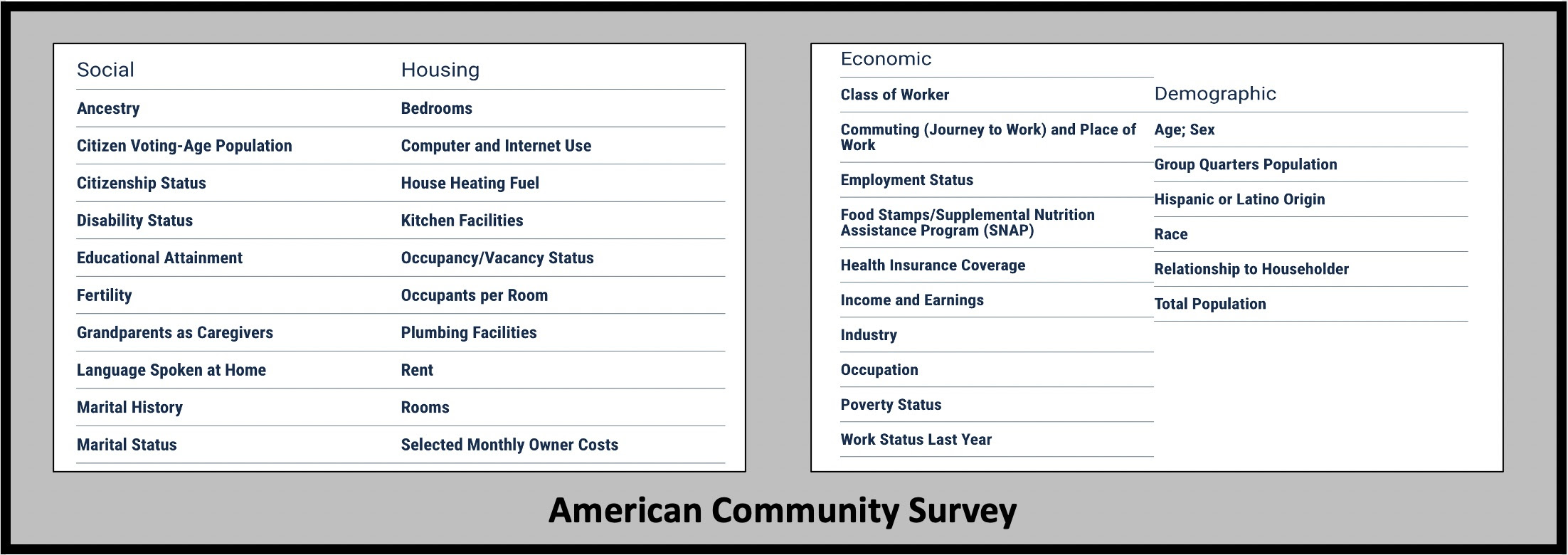
What is the American Community Survey?
“The American Community Survey (ACS) is an ongoing survey that provides vital information on a yearly basis about our nation and its people. Information from the survey generates data that help determine how more than $675 billion in federal and state funds are distributed each year.” It shares data collected by the Census such as:
Voter PAC
VoterPAC aims to register, rally, and empower the rising American Electorate – people of color and younger voters – in California’s Central Valley prior to the 2022 mid-term elections. Their plan is to fight suppression with a Voter Outreach, Training, Education, and Registration (V.O.T.E.R) strategy. The goal is to register and rally the rising American Electorate – people of color and younger voters – in California’s Central Valley.Support voter pac
Resources
- We Draw The Lines – California Citizen’s Redistricting Commission
11.10.21 Assembly Draft Map - 11.10.21 Assembly Shape Files
- 11.10.21 Assembly Equivalency Files
Project FiveThirtyEight – analysis of impact of redistricting
Statistical Atlas – a free mapping app with data by county and tract but may not be as current as American Community Survey
A better way to find and canvas unregistered voters
Free app to mobilize volunteers and voters through local events
Canvas more people from any list with free Glide based apps
Precision canvassing
How the Florida Key Dems located eight thousand unregistered voters
TakeAway: Forget hunches. Use data and maps to plan your campaign – especially after redistricting. ‘Duh’ as Homer might say.
Deepak
DemLabs
Reposted from Democracy Labs with permission.


